Sacred site in the city, paved for profit?

Note:  This walk will go ahead with a modified route to accommodate the high water levels and the closure of the Chaudiere Bridge.  The new route will respect designated danger zones along the riverbank. 

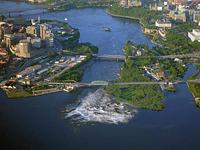
In the Algonquin language (Anishinaabemowin), the waterfalls are known as Akikpautik, and the site including the land/islands as Akikodjiwan and/or Asinabka.  Recently confirmed even by Western archaeology methodology as a particularly significant international gathering space for at least five millenia, the site has been the subject of a planned condominium and commerce development since 2013, despite a large opposition from Algonquin leadership and community members, along with other activists both Indigenous and settler.

This walk will bring together different parts of the stories to protect the islands and waterfront from this development. A special place in the walk will be given to the advocacy of recently-passed Wolf Lake Algonquin Chief Harry St. Denis.

Sign-up requested! 

Please sign up to attend this walk.  If you'd like to ensure there are enough printed handouts for you to receive one, please send an RSVP email to Greg Macdougall if you are planning to attend.   Registration will be accepted beginning April 30.

For some background on the situation with the sacred site and planned development, see EquitableEducation.ca/tag/chaudiere-falls

This walk will be repeated on Sunday, May 5, at 1:00 pm.


Location
Route

We'll meet near the intersection of the Portage Bridge and Wellington St, on small plaza on the north-east corner.  (The meeting place is down the hill from the road and can be reached by steps from Wellington Street or via the bicycle path.) 

From there, we will walk along the waterfront recreational pathway (by the Mill St pub) from the Portage Bridge to the Chaudière Bridge, across the Chaudière Bridge past the provincial border to where the road becomes Eddy St.  At that point, we will turn around and come back to Chaudière Island.  From there we will go west on the Island to the new park located directly adjacent to the ring dam, where there is a new lookout to the falls.   We'll return to the bridge and come back to the Ontario shoreline recreational pathway, turning west to go past the War Museum and walk a short distance upstream.

Note:  The sidewalks on the Chaudière bridge are narrow.  The public park at the dam is mostly a gravel surface, with one paved path.  The nearest publicly accessible washrooms are at the Library and Archives Canada (near start location), and the War Museum (near end location).

About the walk leader

Greg Macdougall is an educator and media-maker who is active in Ottawa-based grassroots efforts on Indigenous solidarity.  These include the efforts to protect the sacred Chaudière site.  Greg is leading this walk to promote understanding of the history and significance of this site, and Indigenous rights in general, on unceded Algonquin territory.

Several special guests are also expected to be in attendance.

Guide:

Greg Macdougall

When:
Date:Sat May 4, 2019
Time:12:00 PM
Duration: 1 hour 30 min
Language: English
Where:
Start:South end of Portage Bridge, \n at Wellington St., NE corner
End:Near War Museum
Area:Lebreton Flats
Distance:1.25 kms
Accessibility:

The walk will follow paved pathways and (sometimes narrow) city sidewalks.

Gallery
A visionary image of the sacred site with re-naturalized Chaudière Island and undammed waterfalls. Chaudière Falls, showing the limestone ledges that create the torrent. The dam and Chaudière Falls with a rainbow from the mist. The meeting place for this walk.
Volunteer to Marshal This Walk