Uplands—Exploring the old Bowesville Road

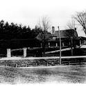
Photo:  The original clubhouse of the Ottawa Hunt Club on Bowesville Road (from the Gloucester Photo Collection).

The old Bowesville Road is one of the most historic roads in the Ottawa area dating back almost to the city's founding. Yet, it is now mostly forgotten. In the early days, it was a life line connecting the wilderness to civilization. Today, officially only half a block remains. As we walk, we will learn about the airport, the Ottawa Hunt Club, the old Canadian Northern Railway and other points of interest now mostly long gone. We will enjoy a leisurely walk tracing some of the remaining fragments of this historic road now superseded by modern Riverside Drive.  

Location
Route

We'll meet at the entrance to the Ottawa Hunt & Golf Club, at the intersection of Hunt Club Road and Bowesville Rd.  From there, we'll walk north passing the golf course club house then continue north onto North Bowesville Road, west on Uplands Drive to Riverside Drive, north on Riverside Drive to Malhotra Court, west to Rivergate Way, and then walk north to the end of the road.   We will walk off the road to reach the railway tracks, with an alternate route to get a better view of the Railway bridge across the Rideau River. 

Most the route is accessible except the very end of the walk towards the railway tracks, which will include walking on uneven ground and crossing a short make-shift bridge over a very small creek.

Please note that parking at the Hunt Club is private and is reserved for members only.

About the walk leader

Glenn Clark is the President of the Gloucester Historical Society. He is a life-long resident of Gloucester South and has memories of the sleepy country roads that at one time ran through the Hunt Club area.  

Guide:

Glenn Clark

When:
Date:Sat May 5, 2018
Time:11:00 AM
Duration: 2 hours
Language: English
Where:
Start:Ottawa Hunt and Golf Club, <p>..............................Hunt Club Road
End:North end of Rivergate Way
Area:Quinterra/Hunt Club
Distance:1.0 km
Accessibility:

Most of the route follows paved roads and pathways.  Towards the end, there is some uneven ground including a short make-shift bridge over a very small creek.

Gallery
Volunteer to Marshal This Walk