Farm Science and the City
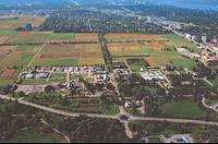
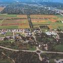
Photo: Aerial view of the Central Experimental Farm, looking west
This walk explores the Western-half of the original 465-acre Central Experimental Farm, from the corner of Carling & Fisher to the NCC Farm pathway and then returning north up Ash Lane to Carling. We will explore the early history of science at the Farm as well the important links between the Farm at Ottawa and Canada's geographically diverse agricultural regions.
This walk will directly confront the challenges facing the Farm today as well as ongoing scientific research. Through these stories, I show that the Farm is worth preserving for future generations not only as an important greenspace within the city, but as a key station in Canada's agricultural research network.
In case you attended this walk in previous years, you should note that the route and content have changed. There will be some overlap with past stories, but as we'll be traversing a completely different part of the Farm, much of the content will be new.