Rue Jacques Cartier: Flood devastation and recovery
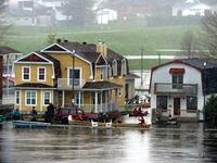
Canoe flotilla transporting sandbags, as waters rise around homes on rue Jacques Cartier, Gatineau
Why build on a flood plain? Join us at ground zero for flooding in our National Capital Region in one of the most beautiful neighbourhoods around. Rue Jacques Cartier, in old Pointe Gatineau, is where you can see the immediate impact of climate change on our urban waterfront development in real time. One of the first neighbourhoods to flood in 2017 and 2019, this neighbourhood hit the national media with images of residents risking their lives to deliver sandbags by canoe. At the same time, well-intentioned politicians used the neighbourhood as a backdrop to question whether flood plains should remain viable for housing when climate change increases flooding risk.
And yet, the history of flooding on this neighbourhood stretches back thousands of years in repeated cycles of flooding and rebuilding. Today, this is a street where houses are being torn down and other flood resistant homes are rising, where architecture is adapting to the challenge, and government planning contradictions are visible.
Various efforts are being made by individual homeowners, some installed after the 2017 flood and others following 2019. These range from pumps and cisterns, grading and other changes to landscaping to encourage water away from foundation walls. Other improvements include wave action mitigation, raising buildings higher above ground, stronger sump well pump systems, and so on. It may be possible to observe the effectiveness of some of these protections installed after 2017 in the face of the 2019 flood.
There are also examples of consequences of government policies and infrastructure choices that may have exacerbated the effects of the recent flooding. For instance, in 1964, the Ottawa River level was raised two meters when the Carillon Dam was built downstream. How much did this higher base water level contribute to flooding since then? Are floods an Act of God alone or humans too? Behind the street is Parc La Baie, ironically named after a former wetland that used to drain flood waters from local properties before it was filled in. Now the reclaimed park area is higher than the rue Jacques Cartier properties, diverting water toward the residences, exacerbating any flooding. The re-developed street and shoreline were originally supposed to act as a dike, but government environmental policy prevented building it higher to protect an unnatural shoreline. In another contradiction, the beaches were buried by rubble by Hydro Quebec with government blessing to protect the street from flooding.
Another interesting note for this neighbourhood is how some road infrastructure has proven to be poorly suited for dealing with the floods. Locations of guardrails and other installations impede paddlers to deliver sandbags, when the City has a policy not to deliver sandbags to the residents along the street. Gates that prevented evacuation of vehicles. And, sandbag facilities were located too far away exacerbated the impact of the flood, putting lives and property at risk thanks to City policy. Some question the intent, as government policies are expediting rue Jacques Cartier gentrification. Old families who lived in the neighbourhood for generations are being bought out of their modest and often poorly maintained homes. New homes and new residents are replacing them.
Certainly, change brings opportunities to re-look at flood plains for enlightened developers and their potential for a new form of architecture, planning, and government policy reform. A visit here will offer a chance to take note of changes that may come faster than we imagine and an opportunity to redesign our notions of urban flood plain redevelopment possibilities.
Mr. Savage will share his observations on the evolving story of this waterfront neighbourhood as we will stroll past homes and the sparkling waters of the Ottawa and Gatineau Rivers.


