The Lost Village of Billings Bridge

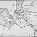
The walk will focus on the former village of Billings Bridge, which was the administrative centre of Gloucester Township from 1850 until 1962. We'll explore the area that used to be the village, and discuss what used to be present there. The village included schools, the Township Hall, fire station, churches, a post office, stores, a blacksmith shop, a carriage works, gas stations, car lots, and an icehouse. None of the original village buildings have been preserved. The last building to be demolished was the Orange Hall, which was taken down in 2023.

Our walk will end at Nordic Circle where we will discuss what was likely Ottawa's most disastrous housing development. All the houses were removed in the mid-1950s and replaced with the park.


Carte indiquant le point de départ
Trajet

We'll meet in front of the Billings Estate National Historic Site at 2100 Cabot St., Ottawa. We'll walk through the original estate gateway, then down the hill that was formerly the Estate's main entrance road to Riverside Drive. We'll cross Riverside Dr. towards the Rideau River, then follow the multi-use pathway west along the south bank of the Rideau River, crossing Bank St at Billings Bridge and continuing west to Nordic Circle (opposite the north end of Data Centre Rd).

The walk will follow paved or gravel pathways. Regarding accessibility of the route, note that there is a fairly steep downhill pathway from the Billings Estate toward Riverside Drive, and we will be crossing the east- and west-bound lanes of Riverside Drive at un-signalled locations. This may make the walk challenging for those requiring mobility devices. 

There is a parking lot near the start of the walk at the Billings Estate. In the event that the lot is closed, there is street parking along Cabot St. in the area of the Billings Estate. There is also parking near the end of the walk in the NCC parking lot off the west-bound side of Riverside Drive at Nordic Circle .

Au sujet du guide

Glenn Clark is the President of the Gloucester Historical Society and a veteran Jane's Walk leader.

  • Link to the Gloucester Historical Society website:


Guide:

Glenn Clark

Quand:
Date:sam 2 mai, 2026
Heure:10h00
Durée: 1 heure 30 min
Langue: anglais
Où:
Début:Billings Estate, 2100 Cabot St
Fin:NCC Parking Lot, Nordic Circle
Quartier:Billings Bridge
Distance:3.0 kms
Accessibilité:

Path incline and road crossings will make the route challenging for mobility devices.

Galerie d'images
The mansion at the Billings Estate National Historic Site. Bank Street looking south from Billings Bridge c. 1900 Bank Street looking south from Billings Bridge c 1970. Gloucester Township Hall, 1874–1962, pictured during spring floods. Newspaper photo of Nordic Circle homes under flood conditions. Village of Billings Bridge—Ruins just east of Bank Street. Auto parade traversing Billings Bridge, during the Grand Opening, September 2, 1915 The plaque describing the Billings Wall (still from the video by Paul Weber).
Portez-vous bénévole pour mener cette promenade